
Tags
Althaus Ck, Bohle, bush medicine, bush tucker, butterfly, crabs, crocodiles, Crown Land, flying fox, George Saunders, Halifax Bay, lanette west, mangroves, surveyors, Townsville City Council, wharves, Wulgurukaba, Yasi

Image 1. Althaus Creek at Saunders Beach where mangroves line both sides in the intertidal zone. March 2011.
We now know that, “approximately 17% of Australia’s mangroves have been destroyed since European settlement, with mangroves near developing centres being removed and destroyed for land reclamation.” [Source]. Previously the enormous environmental value of mangroves was little understood. Just ask any barramundi fisherman about why we need mangroves!
In 1864 the new settlement of Townsville was one such place where removal of mangroves occurred. Townsville’s chief attraction lay in its suitability as a port and the left bank of Ross Creek, near the mouth, became the hub of Townsville’s shipping trade. The first wharves were quickly followed by three galvanised warehouses around mid to late 1865. As early as November 1864 the mangroves on this side had been felled, giving rise to “sticky black mud” with an unpleasant odour [Gibson-Wilde].
The right bank of Ross Creek was Ross Island and dense mangrove wetlands grew there too. South Sea Islanders (also known as the now derogatory term ‘Kanakas’) cleared the mangroves from early 1865 “in an attempt to let more air into the tiny settlement” [Gibson-Wilde].
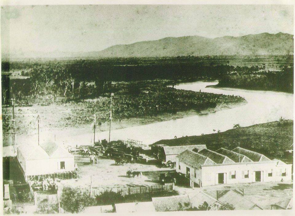
Image 2. This photo comes from Lost Townsville, Inner City Townsville, Queensland Album, (Facebook page) submitted twice: Jaymie Rains, 25 August 2014, title “Ross Creek 1874”. Nev Hoy, 26 August 2015. Title “Ross Creek , Bottom End Of Denham Street. The Mangroves have been cut down on the opposite bank, stumps are still visible.”
Further north at the mouth of the Bohle River George Saunders selected four portions of land over a number of years commencing in 1873. On the plans surveyors have marked stands of mangroves on three of those portions. For example on the plan of Portion 104 where Saunders Creek empties into the Bohle River Surveyor F. Benwell has written: “632 acres including islands and mangroves.”
Further north again in the general area of Saunders Beach Surveyor Sharkey in December 1878 marked only one selection of George Saunders as having coastal mangroves – Portion 241, now the nickel refinery and the last houses in Cay Street (see map in header at top of the page). Since European settlement the mangroves at the mouth of Althaus Creek (in the 2011 photo above) have always been and are still are a Crown Land Reserve (R111).
Prior to that the Wulgurakaba people would have spent at least part of the year in the Saunders Beach environs and would have been able to access bush tucker and bush medicine along the mangrove-lined creeks throughout the seasons.
Thankfully the mangroves at Saunders Beach have survived development and for this we can be grateful as today we are left with a remarkable ecosystem, home to birds, fish, crustacean species, and crocodiles amongst others.
Saunders Beach’s mangroves are mainly the Yellow Mangrove or Ceriops tagal, Family: Rhizophoraceae.

Image 3. Yellow mangroves can reach 10 metres. Their leaves have a distinctive yellowish appearance.
Spiders, snakes and flying foxes live in mangrove wetlands while butterflies feed off the flowers. Crabs live and breed under the roots of the mangroves; prawns and fish such as barramundi and mangrove jack use the nutrient-rich mangroves as nurseries.

Image 4. Mangroves are subject to two tidal inundations a day and have specially devised methods to cope with the salty water. Yellow mangroves have buttressed trunks to stand up to the ebbs and flows.
Lanette West has captured the wonder and mystery of mangroves and translated it into a sense of fun in her artwork as featured in Nature Inspired: Visual Artist Lanette West.
Brahminy kites, sea-eagles and kingfishers common in the skies of Saunders Beach live on the edge of mangroves and hunt fish among their tangled roots. Eastern Reef Egrets feed in shallow water on small fish, crustaceans and insects near the mangroves.
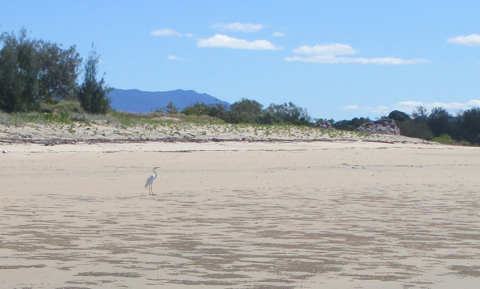
Image 5. This Eastern Reef Egret feeds in the shallow waters off Saunders Beach, adjacent to the mangroves at mouth of Althaus Creek (seen in the far right of this photo).
Returning to Image 1 in this article which features mangroves both sides of Althaus Creek: It was taken in March 2011 after severe tropical cyclone Yasi. (Yasi crossed the coast at Mission Beach, approximately 200kms north of Saunders Beach as a marginal Category 5 in the early hours of 3rd February 2011). Despite much damage sustained to Saunders Beach itself, in Althaus Creek the dense mangrove forest dissipated wave energy, leaving minimal damage.
Nowadays mangroves are protected against all forms of development. The Queensland Department of Environment and Heritage Protection informs us that in the Great Barrier Reef World Heritage Area in 2005, “it has been determined that the mangrove wetlands are resilient: there has been no net decline in area of mangrove wetlands over the last 40 years.”
For which we can be grateful.
References:
http://www.bmrg.org.au/resources/education-resources/marvellous-mangroves/
http://www.bmrg.org.au/files/5414/0721/9505/MarvellousMangoveAustralia_3_HumanImpacts.pdf
Early Townsville history
Brumby, M 2014, Black to Gold, From Gateway to Golden Lands. Charters Towers Archives, Charters Towers.
Gibson-Wilde, DM 1984, Gateway to a Golden Land: Townsville to 1884, Studies in North Queensland History No. 7, History Department, James Cook University of North Queensland, Townsville.
Griffin, H. 2014, Frontier Town, A History of Early Townsville and Hinterland 1864-1884, North Queensland History Preservation Society, Townsville, Queensland.
George Saunders
The Saunders’ Selections
at the Bohle https://saundersbeachhistoryproject.com/2015/07/11/pioneers-3/
at Saunders Beach https://saundersbeachhistoryproject.com/2015/05/27/pioneers/
Yellow mangroves
http://wiki.bdtnrm.org.au/index.php/Yellow_Mangrove
Severe Tropical Cyclone Yasi
http://www.bom.gov.au/cyclone/history/yasi.shtml
Australian Institute of Marine Science
http://www.aims.gov.au/docs/projectnet/mangroves-more-than.html
Queensland Government Department of Environment and Heritage Protection http://wetlandinfo.ehp.qld.gov.au/resources/static/pdf/resources/fact-sheets/profiles/p01867aa.pdf


The Mangrove article is really great reading, we are very lucky that at least some area’s of Mangrove trees survive and thrive not only in the Saunders Beach area but in other locations as well. These trees are such an important part of our ecosystem and the role they play in our environment needs to be understood and appreciated
by us all, now and in the future.
Yes, we sure are lucky at Saunders Beach!
Received by email saundersbeachhistoryproject@yahoo.com
Although they state that Saunders has remained the same, this is not exactly correct.
The below picture [photo not included in this comment] was taken about 30 years ago and is actually the left hand side of the picture of Althaus creek.
The outside bend of the creek (Lh side) was actually a sand bar with a creek behind it.
The creek only ever held water at high tide and used to completely drain out to leave the mud.
When I was a young boy, I used to tie a drag net across the beach side entrance between mangrove stands
As the water ran out so did the bait and I would wander along the net collecting my bait.
it was mainly mullet and snubbed nosed garfish. But occasionally you would catch some larger fish.
It was also one of the only places you could find cone shells with slug in them. Great Bait.
It was very rare that you ever saw any of the rocks that are in the foreground.
They were under about 2mt of sand.
Thank you for sharing your memories of Saunders Beach thirty years ago. Growing up at Saunders sounds like fun.
The current alignment of Althaus Creek is shown brilliantly in the banner image of the Saunders Beach Community Centre Inc Facebook page. https://www.facebook.com/SaundersBeach?fref=ts